When I left off last time I mentioned I would be headed back to my aunt’s house in Sonora California. I learned another hard lesson from this leg of the #payitforwardtour. Know where you are going and stop for gas.
My First Mistakes
On my way out of Cedar City Utah I consulted Google Maps for the best route. I saw the shortest time route was going to save me 3 hours off my previous trip. I decided that was the way to go. This was my first mistake. I should have looked at where the route was taking me. My second mistake was just minutes later. I saw a gas station just a couple miles into the trip. Looking down at my gas gauge, I had over three quarters of a tank. That is plenty I thought. No need to stop for gas yet.
Public Lands No Biggie
Ten miles later, i see a sign that says public lands. Still not worried because I can see houses and civilization, I press on. I travel some of the most beautiful country I have ever seen. I know I say that a lot but it’s true. Reaching elevations of between 4000 ft and 6000 ft. There is woodland, fields and beautiful rocky areas.
Mistake Number 3
A little over an hour into the trip I arrive in Panaca Nevada. A small town seemingly in the middle of nowhere. I turn onto the Great Basin Highway, also known as route 93. There is a Shell gas station directly across the street. I once again check the gas gauge. At this point I have only gone about 80 miles so I am still above half a tank.
Mistake Number 4
Only 15 miles later I come to Caliente Nevada, Another great opportunity to get gas but no, I push on. Little did I know I was about to enter one of the longest stretches of nothing i have ever driven. If you are going to take this route, get gas in Caliente. There should be a sign that says get gas now or regret it later haha.
Ghost Town
About 40 miles from Caliente is a ghost town named Crystal Springs. It happens to be home to the Alien Research Center and nothing else. When I say nothing else I mean 2 abandoned buildings and nothing as far as you can see. Now I am about 140 miles into this trip and still haven’t stopped for gas. I am below half a tank. Passing through a ghost town, I am beginning to wonder if I have made a grave mistake. Now I am thinking I will get gas the next chance I get. I just didn’t know I wouldn’t have a chance for almost 200 miles.
Extraterrestrial Highway
Not long after entering Crystal Springs the route turns onto 318 and then splits off to the Extraterrestrial Highway. Yes folks there is an Extraterrestrial Highway. This highway is aptly named as you will soon find out. Right after entering the highway there is a sign that says Rachel Nevada is 40 miles away. Ok what a relief! I should only be 40 miles from gas. Given the ghost town I had just driven through you would think I would have realized, maybe it was not a sure thing.
Rachel Nevada
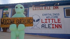 As I was approaching the town I could see just one tiny building with a bunch of other buildings behind it in the distance. If this is Rachel Nevada, I am totally screwed, There is nothing there. When I got close enough to really see what was there my worst fear set in. I hadn’t seen another sign for any towns and there is no gas in sight. You actually may have heard of Rachel Nevada from the big raid area 51 event last fall I happened to drive through 2 days before the event happened. Fortunately it was not much of an event and no one really did anything they shouldn’t Rachel is over 100 miles north of Las Vegas in the Great Basin Desert. The tiny town receives a substantial number of visitors and tourists, catered to by a small tourist shop, a 12-room motel, and an alien-themed restaurant and bar called the Little A’Le’Inn. See what they did there haha. Several unpaved roads near Rachel lead from Highway 375 to the boundary of Area 51. Most of the year-round inhabitants live in mobile homes. Rachel has never had a post office. The children are bused to Alamo, approximately 50 miles away. When people say they live in the middle of nowhere, its the truth for the 50 or so residents of Rachel. I wish I had stopped to take pictures but I was pretty much set on getting somewhere with anything.Hopefully I can go back though now that I know the drill. I think it would be fun to hang out at the A’Le’inn and do a little conspiracy theorist watching. Also, it doesn’t hurt that I am an aviation fan and it is pretty close to Nellis Air Force Base.
I Can See For Miles and MIles and Miles
Now that I am in full panic mode the next, roughly 2 hours of my life, would feel like an eternity. It was getting close to dark and in this area of Nevada the cattle are free range. This means that they freely cross the road. Of course cows aren’t exactly fast but in the dark a black cow is really hard to see. If you have been following my blog from the beginning you will remember a post about a trip Sandy and I took to Death Valley National Park. If not you can read it here Death Valley National Park: This brought back a not so fond memory of that trip haha. I came around a corner that night and there were 10 donkeys crossing the road. Ok back to this trip. The highway is perfectly straight for many miles. You can see forever, which comes in handy when you are hoping to not hit a cow or anything else haha. At one point I noticed that Google Maps said I had a left turn in 24 miles. In the distance I could see a red flashing light. At that moment it never occurred to me that I was seeing my turn, 24 miles in advance. See I told you I could see forever haha.
Red Beacon in the Night
That red light marked the location of Warm Springs Nevada. Yet another ghost town with nothing for as far as the eye could see. Well actually there were mountains to see, and desert, and a lot of brushy vegetation. 2 abandoned buildings and apparently an abandoned hot springs. When I got to the light it was total darkness and not a headlight in sight. In fact I had only seen 6 cars since turning on to the Extraterrestrial Highway. Oh, also, I hadn’t had cell service in over an hour. If I broke down this was not going to be good. I come to my red beacon in the night and turn onto Route 6 This is supposed to take me to Tonopah Nevada. Where I am hoping there is something, because so far I have seen 200 miles of nothing.
Tonopah Bombing Test Range
For the next hour or so I am constantly checking the gas gauge and looking for any lights in the distance. Unfortunately the only lights I saw were from Tonopah Bombing Range airport. Do not go toward these lights as it is a highly restricted government facility. You can check it out here: Tonopah Test Range.
An Oasis in the Night
An hour later I arrived at heaven also known as Tonopah Nevada. I am not sure if you realize yet but I have been driving for nearly 6 hours and haven’t stopped at all That means no bathroom breaks. As I was getting off the highway I was down to my last 2 gallons of gas and needed a bathroom worse than I have ever needed one before. I also hadn’t eaten since Cedar City. I stopped at the first gas station I saw. While the gas is pumping I look up a place to stay for the night because I had enough. I ended up settling on the Tonopah Station Hotel and Casino. It was like strolling into a old western movie. The place wreaked of stale smoke. The hotel is decorated with old wagon wheels, a giant taxidermy bear named james, and lots of other relics from a by gone era. The check in area looked like an old jail. The elderly lady at the desk is the nicest hotel clerk I have dealt with on this trip. When she told me the price of $72 , she said it in an almost apologetic way. At that point I would have paid $700 haha. I have never been so happy to get into a hotel room in my life. After using the facilities I made it to Burger King and came back to hunker down for the night.
Next Up Stanislaus National Forest
Next time I will finish up my trip to Sonora, passing through the beautiful Stanislaus National Forest. Check back in to see pictures of stunning mountains and scenery!

Leave a Reply